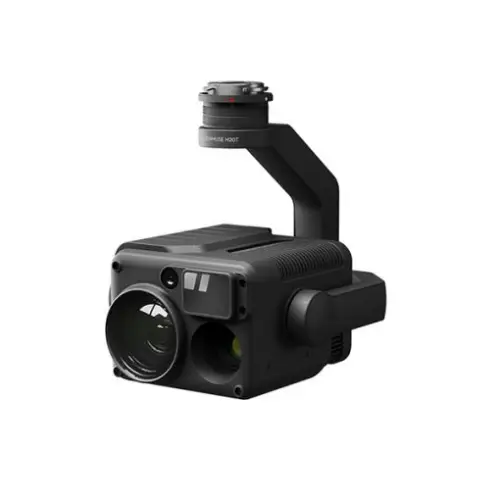
DJI Zenmuse H20T
 |
 |
 |
 |
| 12 MP Wide Camera | 20 MP Zoom Camera | Radiometric Thermal Camera | Laser RangeFinder |
| 82.9° DFOV | 23× Hybrid Optical Zoom | 640×512 px | 1200 m Max Range |
 |
 |
 |
 |
| IP44 Rating | -20°C to 50°C Operating Temperature | Active Image Stabilization and EIS | Night Scene Mode |
Unleash the Power of One with DJI Zenmuse H20T
“H” For Hybrid
In the DJI Zenmuse H20T, multi-sensor payloads bring a whole new meaning to mission efficiency. The unique intelligence and integrated design provide unprecedented aerial imaging capabilities for a range of commercial drone applications. Welcome to DJI’s first hybrid sensor solution – the Zenmuse H20 Series.
All The Sensors You Need – In One
Capture everything. Up close or from a distance. In true living color or thermal. An integrated laser rangefinder (LRF) measures the distance to an object at up to 1200 m away. A powerful, integrated payload that unleashes advanced intelligent capabilities for DJI’s industrial drone platforms.
H20T – Quad-Sensor Solution with DJI Zenmuse H20T
20 MP Zoom Camera
12 MP Wide Camera
1200 m LRF
640×512 px Radiometric Thermal Camera
Closing the Distance
Powerful Zoom Camera
23× Hybrid Optical Zoom, 200× Max Zoom
20 MP 1/1.7” CMOS Sensor
Video Resolution: 4K/30fps
Everything in View
Wide Camera
Equivalent Focal Length: 24mm, DFOV: 82.9°
12 MP 1/2.3” CMOS Sensor
Precise Distance Data
Laser Rangefinder
Range: 3 m – 1200 m
Accuracy: ± (0.2 m + D×0.15%)
See the Unseen
Radiometric Thermal Camera
DFOV: 40.6°
Resolution: 640×512, Frame Rate: 30fps
Thermal Sensitivity: ≤ 50mk@f1.0 (NEDT)
The All-In-One
Multi-Sensor Payloads
See the full picture without missing any details wherever, whenever your mission takes place.
Seamless User Interface
A new integrated user interface lets you quickly switch between wide, zoom, and thermal camera views, and preview the zoom FOV while in wide or thermal camera view.
Intelligent Ways to Collect Data
AI Spot-Check
Automate routine inspections and capture consistent results every time. Onboard AI recognizes the pre-marked subject of interest in subsequent automated missions to ensure consistent framing.
High-Res Grid Photo
Frame an area of interest in wide camera view, and the zoom camera will automatically capture a set of 20 MP images of the area. These images are stored together with an overview image that can be viewed in greater detail.
PinPoint
A quick tap marks an object in view, advanced sensor fusion algorithms immediately deliver its coordinates.
Smart Track
Identify and follow moving subjects like people, vehicles, and boats with the auto-zoom function, while continuously acquiring the subject’s dynamic location.
Visualize Temperatures Immediately
Accurate Temperature Measurement
Monitor the temperature of a site or an asset to eliminate any risks by acquiring a precise temperature reading from the air.
Spot Meter
Tap a point to get a real-time reading of the surface temperature.
Area Measurement
Select an area to view the lowest, highest, and average temperatures
Reviews & Ratings
Related products

DJI Matrice 300 RTK

M300 propeller

Matrice 30T

Mavic 3 Enterprise Series

DJI AGRAS T30 INTELLIGENT BATTERY

M30 Propeller

Matrice 30

DJI Phantom 4 RTK

Autel Smart Controller V2

DJI AGRAS T10
Product Queries (0)
Login or Registerto submit your questions to seller
Other Questions
No none asked to seller yet
Top Selling Products


DJI MINI 3 COMBO PLUS

DJI Mavic 3 Classic with RC

DJI MINI 3 Pro With DJI RC

DJI MINI 3 Pro
Top Selling Products
DJI MINI 3 COMBO PLUS
DJI Mavic 3 Classic with RC
DJI MINI 3 Pro With DJI RC
DJI MINI 3 Pro
About
Contacts
-
Address
Office 203, Al Tayer Commercial Building, Rolla Street, Bur Dubai, UAE
-
Phone
+9714 2238380 / +97150 157 6093
-
Email
-
Whatsapp
My Account
Customer Service
Subscribe to our newsletter for regular updates about Offers, Coupons & more
Follow Us
-
Address
Office 203, Al Tayer Commercial Building, Rolla Street, Bur Dubai, UAE
-
Phone
+9714 2238380 / +97150 157 6093
-
Email
-
Whatsapp